
Hi the
Having a 100 year old cottage to get into a liveable state turned out to be a wonderful blessing in disguise. With lockdowns in place, there was no guilt or worry about missing out on adventures and instead we could focus on renovating. That of course has lead to a bit of a downturn in productivity on this blog so apologies for that.
Last week I enjoyed a bit of time off from work. Since COVID struck, work has been absolutely mental busy and I guess the stress of that combined with the upturning of life as we knew it, as well as the slog of renovating took it’s toll and I had started to burn out. We had just finished the majority of renovating and had moved in a few days earlier so having a bit of time away from work to just enjoy our new home and spend time with Lachie was just what the doctor ordered.
Of course having a week off meant there was potential to get out and about into the great outdoors! With lockdowns eased, I was giddy with excitement to be back in the bush once more. I ummed and ahhed over where to go, knowing I couldn’t go tooooo far or for too long as had to be back to pick up Lachie from childcare. I settled on Collins Cap, one of the few remaining peaks in Wellington Park we’d yet to climb.
You get to the start of the trail by driving out of Hobart towards Collinsvale, a small town in the foothills of Mount Wellington with a strong German past. It used to be called Bismarck after Otto von Bismarck, the then-Chancellor of Germany in the early 1880s.
Just outside Collinsvale you make your way towards the Myrtle Forest picnic area and park near the boom gate marking the start of the walk. We’d been this way before on our way to Trestle Mountain so I remembered the slog getting up to the fire trail at the base of Collins Cap. This would have been a fairly easy walk a few months back when we were hiking regularly but fitness levels have certainly dropped off since!
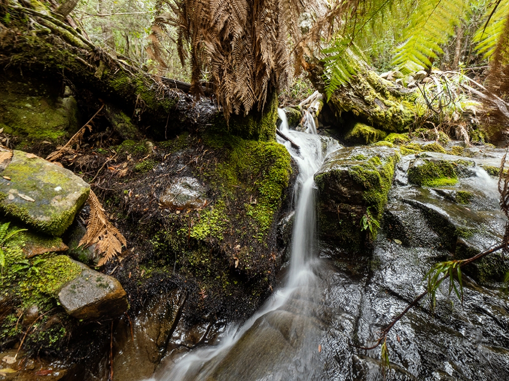
The walk up through the Myrtle Forest is stunning with wet rainforest all around you and the constant trickle of water flowing over seemingly endless small waterfalls along the creek. Eventually the dampness of the rainforest gives way to the sub-alpine zone and the vegetation changes distinctly. It’s always an exciting part of climbing mountains as you know you’re getting up and into the high country. The first thing you notice is the trees that were towering above you at the base start to get lower and lower until you can reach up and almost touch their crowns. The thick ferns and mosses give way to hardier scrubbier vegetation built for a more punishing climate.
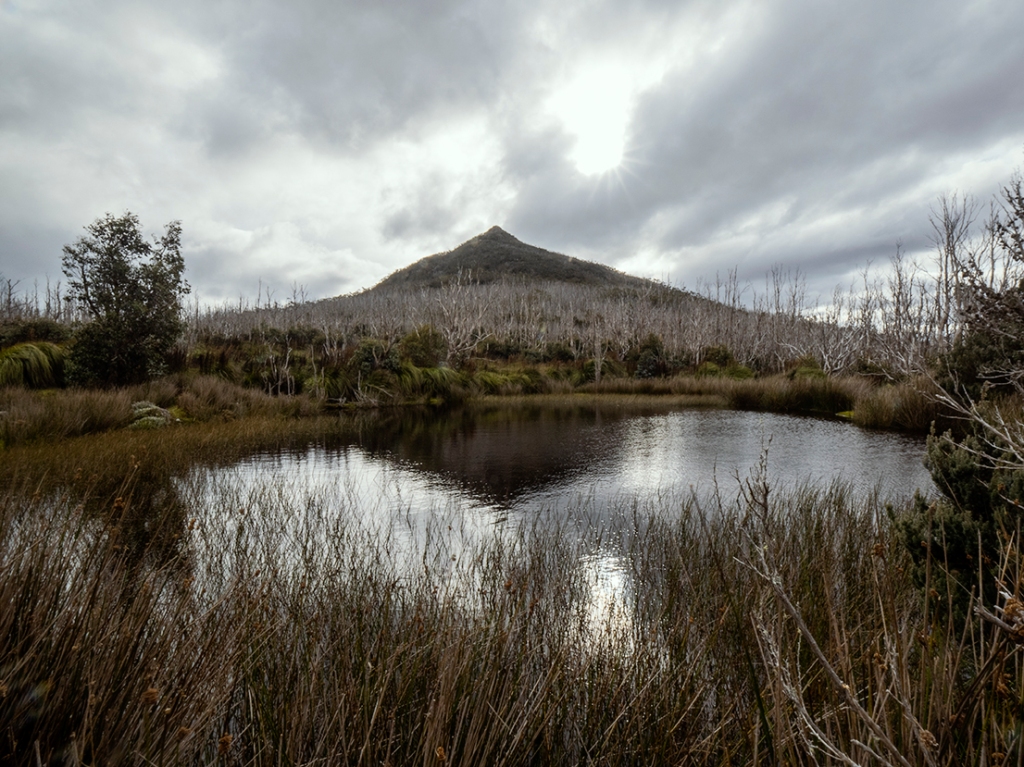
The Myrtle Forest track eventually takes a right fork to the Collins Cap track before arriving up onto the comparably super wide Collins Cap Trail, a 4WD track that frees you from the claustrophobic tracks on the way up. I highly recommend taking a slight detour down to the left along this trail and check out the water reservoir at the base of Collins Cap. It offers fantastic reflections of the mountain and gives you a moment to rest before heading up the Cap.
Alright, enough faffing about, let’s get to the top! The last stretch of the Collins Cap track starts off rather sketchily with some very slippy sections. You’ll want to reach out to a branch or two at the sides to stop any unwanted mud bathing. Thankfully I got past this unscathed and continued onwards and upwards. I’m not sure how I did it but somehow I got a little lost on the way. I had been keeping an eye on my foot placement and before I knew it the track had run out and I was faced with some impassable scrub. A quick check of the area on my phone and I was back on track. Phew. It’s a popular track and is well defined but just shows you how easy it is to get disoriented when bushwalking.
The summit, like many of the peaks in this area seems to just pop up out of nowhere. There’s a short scramble up some large boulders, the temperature drops suddenly, the wind picks up and you’re there. A large rock cairn marks the summit and there’s a couple of spots to sit down and take it all in. The most impressive sight from the summit is Collins Bonnet with its exposed rocky top jutting out above the forests below. You can also catch the edge of the Tasman Bridge making its way over the Derwent river towards Hobart. On a clear day you can see out to the mountains beyond and Tassie’s highest peaks.
To say it felt good to be back in the mountains is an understatement! It was a much needed re-connection with nature as I’d started to feel a bit distant from Tasmania having not been beyond the city for weeks and weeks. I can confirm it’s as beautiful as ever out there and while the tourists are away, it’s never been a better time to explore our island home.


I decided to focus a bit more on video for this one and put the below little piece together. Enjoy 🙂
Source link